Occultation by Pluto (2018-08-15)
Important : If you plan to observe, please download and read the protocol in order to prepare the observation. It will help us to standardise the post-treatment. If you succeed in the observation, please fill the report by following the instructions.
News: (2018.07.13) new updated prediction
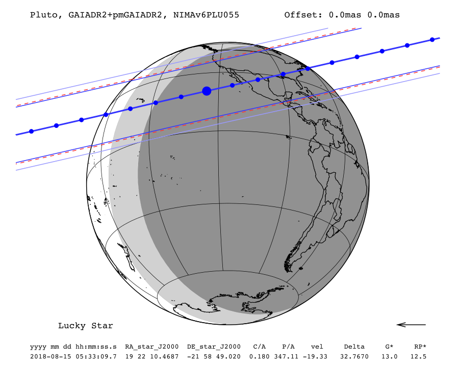
Occultation map
General map
Zoomed map with elevation lines
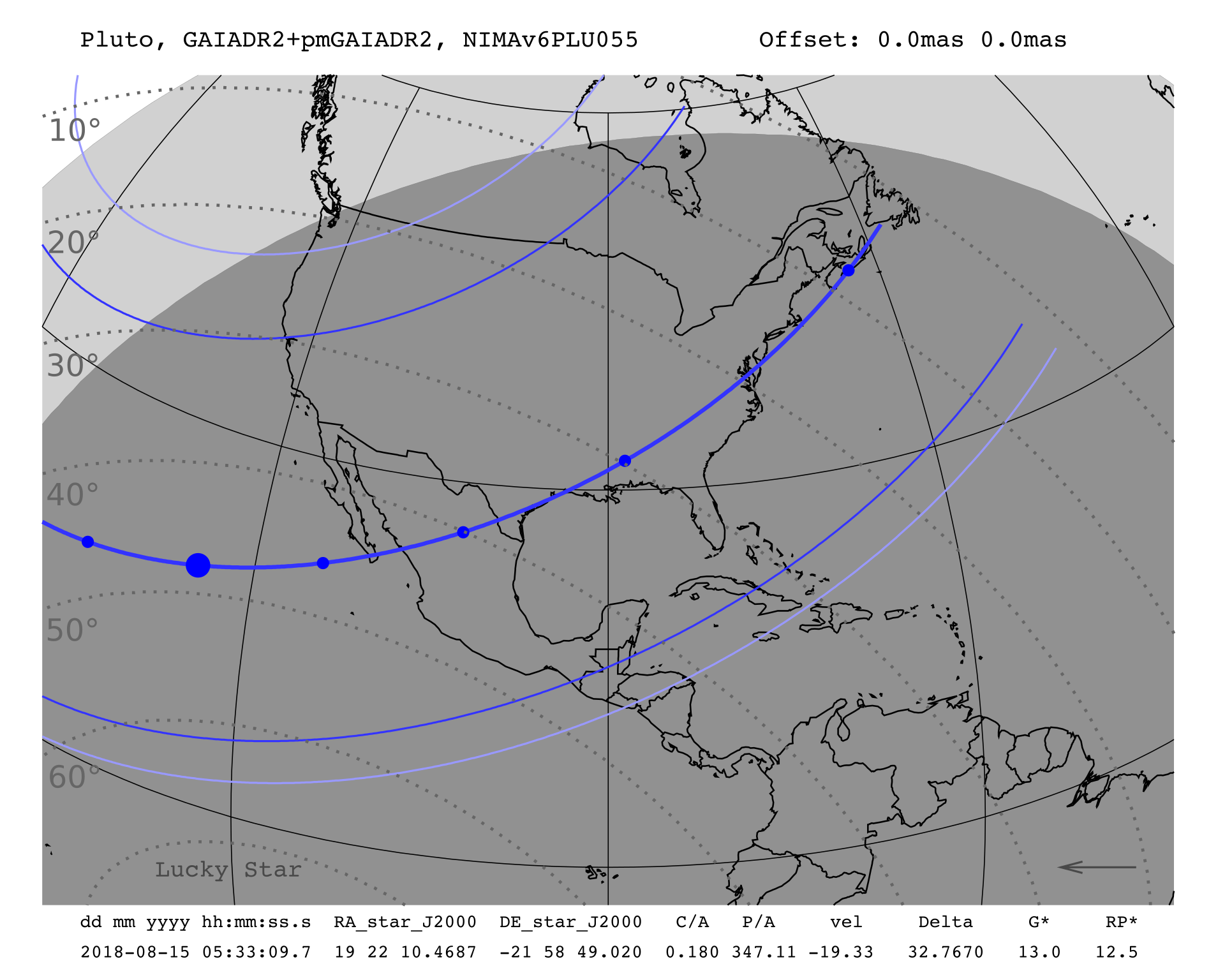
Information about the map:
- The straight and continue dark blue lines are the shadow limits considering the estimated radius (corresponding for Pluto half-light level where the star's flux will be reduced by 50%). The light blue lines are the 1% stellar drop (the theorical limit of detection of the occultation);
- Each blue dot is spaced by one minute and the big blue dot corresponds to the nominal occultation time (which is the geocentric closest approach);
- The arrow shows the direction of the shadow motion;
- The 1-σ precision along the path is represented by the red dotted line;
- The star G* and RP* are the G (from Gaia) and RP (red photometer from GaiaDR2) magnitudes, normalized to a body moving at 20km/s in order to enhance very slow events;
- The body offset is at the upper right corner, if JPL ephemeris is used;
- Areas in dark grey correspond to full night (Sun elevation below -18 degrees) and areas in light grey correspond to twilight (Sun elevation between -18 and 0 degrees) while daytime is in white;
- Be careful, the dates are from the moment of the event in Universal Time, the night of the event may begin at the date before.
Occultation circumstances
| Date | Wed. 15 Aug. 2018 05:33:09 |
| Star position (ICRF) | 19 22 10.4687 -21 58 49.020 |
| C/A | 0.180 arcsec |
| P/A | 347.11 ° |
| velocity | -19.33 km/s |
| Geocentric distance Δ | 32.7670 au |
| G mag* | 13.0 |
| RP mag* | 12.5 |
| Magnitude drop | 1.8 |
| Uncertainty in time | 4.1 sec |
| Uncertainty in C/A | 2.5 mas |
| Uncertainty in projected distance | 59.9 km |
| Probability of occultation on centrality | 100.0% |
| Maximum duration | 126.2 sec |
| Moon distance to the object | 94.7° |
| Fraction of illuminated Moon | 19.5 % |
| Solar elongation | 146.6° |
Sky map (Aladin)
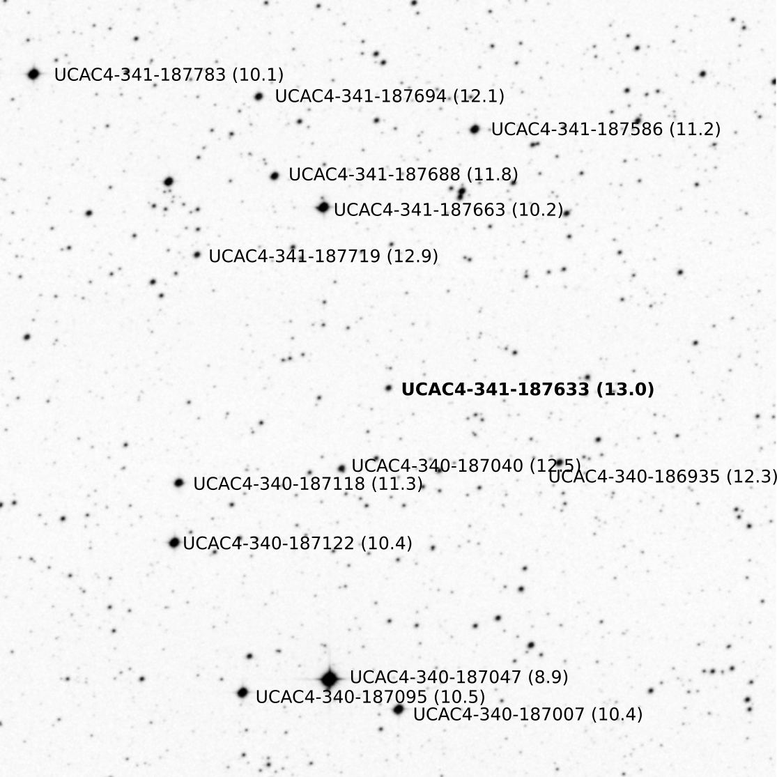
DSS Field of View (15' x 15')
Download the FOV image -- clear version -- annoted version
Interactive Google Maps
The red line represents the centrality of the occultation.
The green lines represent the half-light level where the star's flux will be reduced by 50%. The blue lines are the 1% stellar drop (the theorical limit of detection of the occultation).
The path goes from East to West.
By clicking on one place, you will have an infobox with :
The path goes from East to West.
By clicking on one place, you will have an infobox with :
- Coordinates: longitude and latitude;
- Δd: projected distance to the central line;
- mid time: mid time of the occultation at the selected place;
- duration: expected duration of the occultation at the selected place (assuming a radius of 1216km);
- Sun elevation: Sun's elevation above the horizon at the selected place at the mid time.
- Pluto elevation: Pluto's elevation above the horizon at the selected place at the mid time.
Links
Previous updates
- 2017-Dec-17 20:02 : JPLDE436PLU055, GAIADR1, UCAC5
- 2018-Apr-30 18:03 : JPLDE436PLU055, GAIADR2, GAIADR2
- 2018-May-25 17:18 : NIMAv5PLU055, GAIADR2, GAIADR2
- 2018-Jul-13 15:16 : NIMAv6PLU055, GAIADR2, GAIADR2 current version