Occultation by 2002TC302 (2021-11-11)
This occultation has a more recent update available here
Occultation map
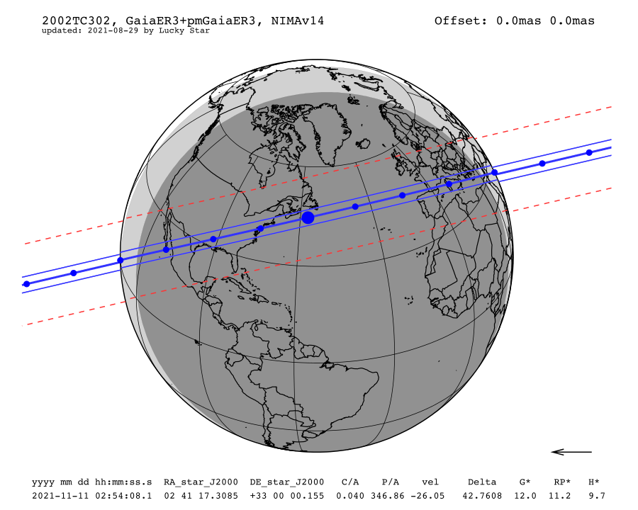
Information about the map:
- The straight and continue lines are the shadow limits considering the estimated radius; when the shadow crosses the Earth's surface, the path is projected on the Earth;
- Each blue dot is spaced by one minute and the big blue dot corresponds to the nominal occultation time (which is the geocentric closest approach);
- The arrow shows the direction of the shadow motion;
- The 1-σ precision along the path is represented by the red dotted line;
- The star G* and J* are the G (from Gaia) and J (from 2MASS) magnitudes, normalized to a body moving at 20km/s in order to enhance very slow events;
- The body offset is at the upper right corner, if JPL ephemeris is used;
- Areas in dark grey correspond to full night (Sun elevation below -18 degrees) and areas in light grey correspond to twilight (Sun elevation between -18 and 0 degrees) while daytime is in white;
- Be careful, the dates are from the moment of the event in Universal Time, the night of the event may begin at the date before.
Occultation circumstances
| Date | Thu. 11 Nov. 2021 02:54:08 |
| Star position (ICRF) | 02 41 17.3085 +33 00 00.155 |
| C/A | 0.040 arcsec |
| P/A | 346.86 ° |
| velocity | -26.05 km/s |
| Geocentric distance Δ | 42.7608 au |
| G mag* | 12.0 |
| J mag* | 11.2 |
| H mag* | 9.7 |
| Magnitude drop | 8.6 |
| Uncertainty in time | 63.3 sec |
| Uncertainty in C/A | 33.4 mas |
| Uncertainty in projected distance | 1034.8 km |
| Probability of occultation on centrality | 19.1% |
| Maximum duration | 19.2 sec |
| Moon distance to the object | 95.9° |
| Fraction of illuminated Moon | 45.6 % |
| Solar elongation | 163.5° |
Star & Object data
Occulted star
| Star source ID | 133768513079427328 |
| Stellar catalogue | GaiaER3 |
| Star astrometric position in catalogue (ICRF) | 02 41 17.3062 +33 00 00.185 |
| Star astrometric position with proper motion (ICRF) | 02 41 17.3085 +33 00 00.155 |
| Star apparent position (date) | 02 42 37.1179 +33 05 37.856 |
| Proper motion | μRA* = (5.1 ± 0.0)mas/yr; μDEC = (-5.1 ± 0.0) mas/yr |
| Source of proper motion | GaiaER3 |
| Uncertainty in the star position | RA* = 0.1 mas; DEC= 0.1 mas |
| G magnitude | 11.7 |
| RP magnitude (source: GaiaER3) | 11.0 |
| BP magnitude (source: GaiaER3) | 12.3 |
| J magnitude (source: 2MASS) | 10.0 |
| H magnitude (source: 2MASS) | 9.4 |
| K magnitude (source: 2MASS) | 9.2 |
| RUWE (source: Gaia) | 1.00 |
| Duplicity flag (source: Gaia) | false |
Objet
| Object | (84522) 2002TC302 |
| Diameter | 500.0 km |
| Apparent diameter | 16.1 mas |
| Object astrometric position (ICRF) | 02 41 17.3078 +33 00 00.194 |
| Object apparent position (date) | 02 42 37.1171 +33 05 37.895 |
| Uncertainty in position | RA* = 46.4mas DEC = 42.3mas |
| Apparent magnitude | 20.3 |
| Ephemeris | NIMAv14 |
| Dynamic class(1) | res2:5 |
| Semi major axis | 55.9 au |
| Eccentricity | 0.299 au |
| Inclination | 35.0° |
| Perihelion | 39.1 au |
| Aphelion | 72.6 au |
(1) Data from the johnston archive list.
Sky map (Aladin)
link to sky-map
For declination above -25 °, Pan-STARRS survey is displayed by default whereas below -25 °, DSS is displayed.
For declination above -25 °, Pan-STARRS survey is displayed by default whereas below -25 °, DSS is displayed.
Interactive Map
The large blue line represents the centrality of the nominal prediction. The thin blue lines represent the body's limits of the nominal prediction. Red dotted lines show the 1-σ uncertainty on the body's limits. The white area represents the daylight part on Earth and the blue area represents the region on Earth where the object is not visible.
The shadow at nominal time is displayed. The Sun symbol indicates the place where the Sun is at the zenith at the nominal time. The star symbol indicates the place where the occulted star is at the zenith at the nominal time. Grey zone represents the night area.
By clicking on one place, you will have an infobox with :
By clicking on one place, you will have an infobox with :
- Coordinates: longitude and latitude;
- ρ and Δd: Impact parameter (i.e. projected distance to the central line) and σ distance; Δd is (ρ-r)/σd where r is the object radius and σd is the uncertainty in distance;
- mid time: mid time of the occultation at the selected place;
- expected duration: expected duration of the occultation at the selected place;
- Probability: Probability to observe the occultation on the specified place. This depends on the distance to the centrality, the size of the object and the uncertainty in the geocentric closest approach;
- Object elevation: Object's elevation above the horizon at the selected place at the mid time.
- Sun elevation: Sun's elevation above the horizon at the selected place at the mid time.